These routes have been selected to keep you safe and give a smaller search area for rescue. There are no short cuts and all the check points must be observed. On island routes, a numbered tag must be left whenever a checkpoint is passed (including on return legs) and at the run finish.
Running checkpoints are placed on features as per the provided descriptions. Six-figure grid references are also provided for clarity, but please remember that these numbers describe a 100x100m box containing the checkpoint, rather than its specific location.
Ordnance Survey Sheets: 48 Ben More and 49 Oban and East Mull; 61 Jura; 69 Arran (all 1:50,000) or equivalent 1:25,000 O/S maps are required for each runner, must be laminated or carried in a waterproof case
Oban Course Route
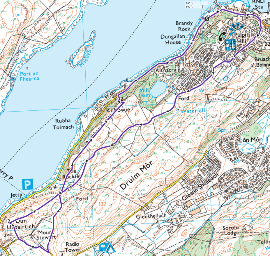
The race starts with a run from the roadside at Oban Sailing Club heading North along the shore road. Note, there will be marshals at all road junctions and the hill summit. The route will not be flagged but will be marked with yellow spray paint. Bear right up Glenmore Road and up the steep Haggart’s Brae to re-join Glenmore Rd. Bear right at the top and then left onto Pulpit Drive. After 100m, take the path signposted `Footpath to Kerrera Ferry’. One mile later, Kerrera Sound comes into view. Do not take the path to the ferry but keep left and follow the cart track which continues to head SW, skirting around a new croft development.
On meeting the lane, turn right through gate and head downhill. Towards the bottom, at a sharp LH bend, leave the lane and head for the marshal on top of Dun Uabairtich. After leaving the top runners must pass to the left of all fences. No gates, stiles or fences should be crossed on the return route. Descend to cross Kerrera Ferry footpath and after 150 metres climb left up left hand fork in footpath towards cliff tops. On approaching the cliff top, beware of dangerous gulley and head NW (right) along the cliff top path and continue to take the upper path along the cliff top. Eventually further progress is blocked by a fence/stile and the path turns left down a prominent gulley above Kilbowie.
Take care re-joining the road at Kilbowie and return along the shore road to the Oban Sailing Club House. Please ensure that you cross the finishing line together. The first pair of runners home wins the Oban Slip Trophy. Runners cross the finish line before heading for their yacht’s dinghy and their crewman waiting on the beach between the Sailing Club Pier and the Borrow Boats Pier. Before boarding their dinghies, runners and crew must don and secure their lifejackets.
MULL YOUTH RUN ROUTE

YOUTH TEAM COURSE
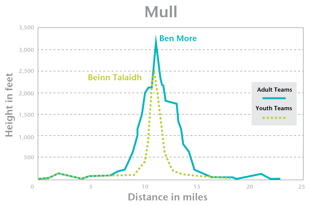
Land at Salen control point in the bay past the first old pier and close by the few remaining stumps of the derelict pier (NM 578 441). The area between the old pier and the control point is the curtilage of the cottages to the side of the pier and therefore must not be crossed by runners. After the 5 minute kit check by marshals and allocation of the tags run to Salen and then along the B8035 to Knock and then left along the track on the SW of Loch Ba to tag check point at the forest road/track junction (NM 568 371).
SENIOR AND YOUTH TEAMS DIVERGE HERE
After the check point (NM 568 371) continue up the Glen Cannel river and pass the old burial ground into Coire Bhain, climbing to the check point on the summit of Beinn Talaidh (750m) (NM 625 347). Descend NW via the check point at Tomsleibhe bothy (NM 617 372). Continue to Salen Control point and hand in your final tag. Sail by any route to Craighouse Jura.
JURA YOUTH RUN ROUTE

YOUTH TEAM COURSE
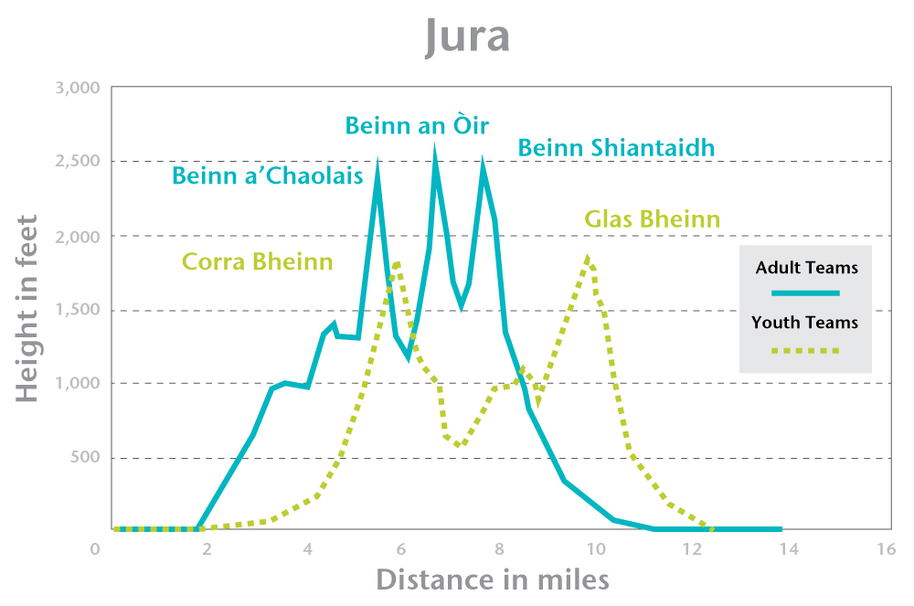
(N.B. The dangerous cliffs and unstable boulder fields on the Paps need extreme care.) Land on or between Craighouse timber pier and the old stone pier. Check in at the Community Hall control point along from the Jura Hotel.After the 5 minute kit check by marshals and allocation of the tags, take the road NE on The Long Road.
SENIOR AND YOUTH TEAMS DIVERGE HERE
Continue NE along the road to the three arch bridge check point (NR 544 720). Ascend to the second check point on the SE summit of Corra Bheinn (NR 526 755). Note that on the OS 1:25K map the SE spot height is incorrectly marked 100m further along the ridge (1:50K, OSM and Harveys are all correct). Carefully descend SSW to Loch an t-Sìob’ and then on to the third check point at the S end of the southern-most lochan in the group of five lochans Cnuich Charrach (NR 510 718). Keep heading SSW to the fourth and last check point cairn on the summit of Glas Bheinn (561m) (NR 500 699). Descend by the old graveyard at Kiels to the point where the Kiels track meets the road at (GR529 683) and return to Craighouse along the road to hand in your final tag at the Jura Community Hall control point. Sail by any route to Arran.
ARRAN RUN ROUTE (Youth and Senior)
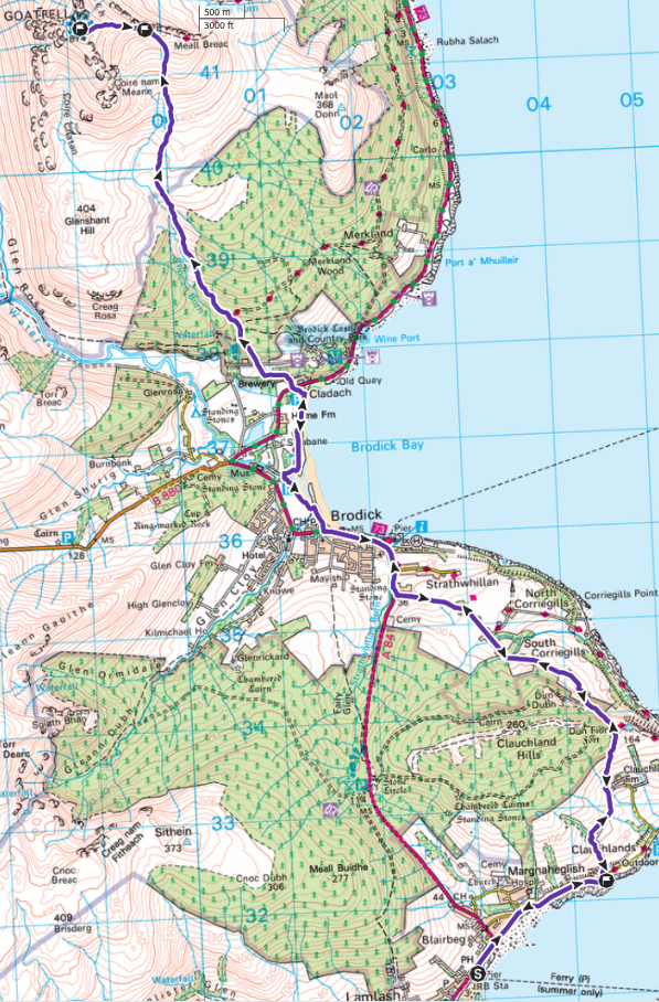
Land at Lamlash Pier. Note that the area round the pier is surrounded by moorings and the water is very shallow close to and west of the pier. At night, the pier will be marked by yellow flashing lights.
After the 5 minute kit check at the control point by marshals and allocation of the tags, take the A841 E from the pier. Leave it where it turns N and follow the coastal lane. At the lane junction checkpoint (NS 043 322) turn left on to the track up Prospect Hill and run north past Clauchlands Farm, where the path crosses open fields to join the Arran Coastal Way. Follow the track until it joins the lane via South Corriegills. Re-join the A841 at NS 022 353. Proceed via the Brodick waterfront path to join the track ascending Goatfell. Ascend via the check point where the track meets the ridge (NR 998 415). Proceed via the upgraded path to the Goatfell summit trig checkpoint (NR 991 415) and return down the same route. Final checkpoint is at (GR043 323). Tags must be left at the ridge (NR 998 415) and at the first checkpoint (NS 043 433) both out and home (5 checkpoints total). The scree route must not be used (at the request of the National Trust) and please keep to the paths. Return to Lamlash control point via your inbound route (South Corrigills and Claughands Farm) to hand in your final tag to the marshals. Sail to Troon.
